3D Laser Scanning
Point Accuracy with Acklam
3D Laser Scanning (3DLS): Provides solutions using 3DLS technology to capture rich datasets in a fraction of the time of traditional survey methods.
With 3DLS, time, efficiency, and safety are three main areas in which this technology can save time on projects of all sizes. Applied to multiple market sectors, 3DLS is used seamlessly across various different software platforms. Acklam can tailor a solution to meet any project need such as:
- Civil
- Pipeline
- Mechanical and Structural Design
- Reverse Engineering
- 3D Documentation on Historical Sites
- Forensic Crime Scene Evaluation
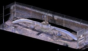
3DLS Laser Scanning Project
Details: Acklam, Inc. Land Surveying and Mapping, led by Lawrence Sinco and Scott Williams, verified onsite control and set additional points for the Leica P40 Laser Scanner to locate during its six setups for the 250-foot-long siphon. The purpose of the scan was to check for any possible deformations throughout the existing concrete siphon that might cause conflict with a smaller diameter pipe that is to be slip lined through the siphon. Scott was able to tie the new scan to a laser scan that had been performed 4 years ago using existing site control.
Read More