 360° Coverage with Acklam
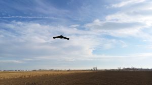
Environmental changes can cause great shifts in topography. Having a precise picture of the land layout and conditions is imperative for any project. This technology is being utilized more commonly across major projects and Acklam provides an expert team of FAA certified sUAS pilots to provide all aerial mapping services. Close Range Aerial Photogrammetry utilizing sUAS: Our team provides tailored solutions using our in-house, fixed-wing sUAS. This aircraft is capable of capturing large coverage areas in a short amount of time with the use of close-range aerial photogrammetry technology.
This technology meets many project requirements such as:
- Ortho-rectified, high resolution background image (Orthomosaic)
- Site-specific background images
- Linear (corridor) Mapping
- Transmission line survey
- Renewable energy resource survey such as wind or solar
- Topographic Surveys of small, large or inaccessible terrain
- Cut/Fill Analysis of stockpiles for value calculations
- Verification of Grade Elevations for QA/QC of Earthworks
- Capturing As-Builts for Documentation or upcoming renovations
- Progress monitoring
Benefits of Using sUAS:
- Increased efficiency
- Improved safety
- Applies to various market sectors
- usable across various software platforms